Orange snowfall warning for high country

MetService New Zealand has today upgraded a snow watch to an orange Heavy Snow Warning valid until 3pm Wednesday
Ashburton District Council’s emergency management team are monitoring the situation.
There's a minimal chance of upgrading to a Red Warning.
Snowfall levels
Canterbury high country and the foothills north of the Rangitata River can expect 30 to 40 cm of snow to settle above 400 metres, with lesser amounts down to 300 metres.
Expect an additional 7 to 12 cm of snow to settle above 400 metres, with lesser amounts down to 300 metres.
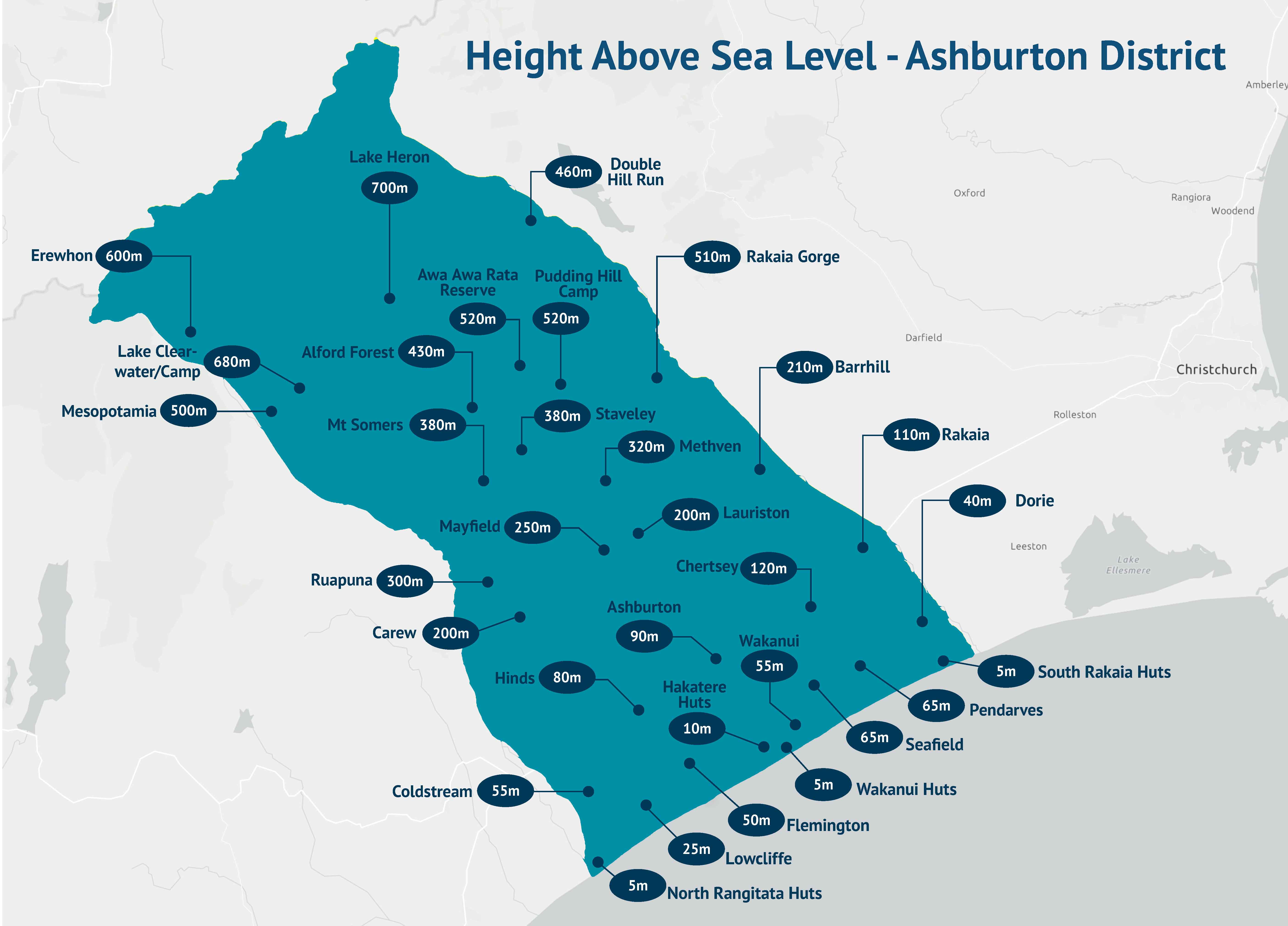
Staveley and Mt Somers are at 380m, Methven is at 320m, Ashburton 90m.
Check your location height above sea level map.
Roading
Wednesday 3pm: All roads and bridges are now open. Travel with care, and drive to the conditions.
Wednesday 8.30am Ashburton Gorge Road - some bridges and corners still have snow all over the road. We are currently organising signage to warn motorists of skid hazards as we hope to open the road later this morning. We are monitoring continued snowfall here.Arundel Rakaia Gorge Road has some snow and ice between Staveley and Rakaia Gorge and we are currently clearing this.The bridge over Ashburton River North branch remains closed and this will stay closed until we get some water filled barriers to protect damaged railing where an accident occurred last night. We will have this open around lunchtime today. This means Arundel Rakaia Gorge Road is closed between Forks Road and Pudding Hill Road. Detours are in place.
Tuesday 6.40pm: We are currently closing Arundel Rakaia Gorge Road between Forks Rd and Pudding Hill Road. Please avoid all non-essential travel overnight on the road network above 300m elevation due to snow/ice.
Tuesday 5pm: The road to Ashburton Gorge, near Mt Somers was be closed as a precautionary safety measure due to heavy snow. There will be access in place for residents. We will reassess conditions after snow clearing with the grader tomorrow morning and provide a further update then.
Click on the link below to open our live and interactive road closures map with details of current and upcoming closures in the Ashburton District:
http://ashburtondc.govt.nz/road-closure-map
State Highways
Waka Kotahi is monitoring state highways throughout the South Island and has the latest closures and conditions on its Journey planner | Waka Kotahi Journey Planner (nzta.govt.nz)
What to do
- Stay up to date with the latest weather information from metservice.com/warnings
- Keep emergency supplies in your vehicle, including warm clothes, sleeping bags and blankets.
- Postpone outdoor activities.
- Seek shelter and bring pets indoors or into shelter.
- Drive only if it is absolutely necessary. It only takes a few centimetres of snow on a road to make driving dangerous. Avoid travel until conditions have improved.
- If you need to drive during snow conditions, stay up-to-date with the latest weather information from MetService including Road Snowfall Warnings, and check traffic and travel updates from Waka Kotahi (New Zealand Transport Agency) before you go.
Share this article
Latest News
Lake Hood closed until further notice due to algal bloom
New shared reception area coming to AAGM
MAYOR: Big water services decisions ahead, have your say
Local Water Done Well: Check your mailbox for info packs
NZTA: SH1 Rakaia speed consultation opens
Road Closures
TREVORS ROAD
from 7 Apr 7:00 to 27 Jun 18:00
FRISBYS ROAD
from 28 Apr 8:00 to 28 Apr 19:00
FRISBYS ROAD
from 6 Apr 8:00 to 6 Apr 19:00
MICHAEL STREET
from 7 Apr 8:00 to 7 Apr 17:00
EALING MONTALTO ROAD
from 14 Mar 0:00 to 5 Apr 0:00
View all Road Closures | Live map
